he Geomatics Laboratory has a wide range of advanced surveying equipment, enabling different types of surveys to be carried out: from the measurement of individual points to the three-dimensional reconstruction of buildings, infrastructure and environments, from satellite positioning to the accurate determination of elevations.
The availability of different technologies makes it possible to select and integrate the most appropriate instruments for specific applications, directly plan and manage surveying campaigns, and oversee the entire workflow, from data acquisition to processing, analysis and interpretation.
Instrumentation is a key component of the Laboratory’s activities. In addition to supporting surveying operations, it enables the development and testing of methodologies, the integration and comparison of different techniques and results, and the hands-on training of students in the use of geomatics technologies.
Topographic Surveying
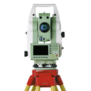
Leica TPS1200 Total Stations
The Laboratory is equipped with four Leica TPS1200 total stations: one with an angular accuracy of 1″, one of 2″ and two of 5″. These instruments measure angles and distances and enable the accurate determination of point coordinates within a reference network.
They are used for topographic surveys of the built and natural environment, the establishment of control networks, traversing and setting-out operations, and the positioning and monitoring of elements and structures. The acquired measurements can be used to obtain three-dimensional coordinates, plans, profiles and geometric models.
The availability of multiple instruments also makes it possible to organise teaching activities and surveying campaigns with several working groups, as well as to test and compare different acquisition configurations and procedures.
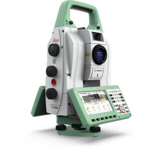
Leica Nova MS60
The Leica Nova MS60 combines the capabilities of a total station and a laser scanner, allowing both individual points measured using conventional surveying procedures and three-dimensional point clouds to be acquired within the same survey.
This combination makes it possible to integrate high-precision point measurements with extensive geometric documentation of the surveyed surfaces. The acquired data can be used to generate point clouds, three-dimensional models, sections and profiles.
The instrument is suitable for surveying and documenting buildings, infrastructure and complex surfaces, particularly where it is useful to combine measurement accuracy, geometric detail and an overall view of the surveyed object.
Satellite Positioning
Leica GS18 I
The Leica GS18 I is a GNSS receiver integrating a camera and inertial sensors. In addition to determining positions during field surveys, it can acquire georeferenced images from which the coordinates of points and details visible in the scene can subsequently be determined.
This approach is particularly useful for documenting and measuring features that are difficult to access or points that cannot be directly occupied with a survey pole. GNSS information and images are referenced to the same coordinate system and can be used together during subsequent data processing.
The instrument therefore complements conventional GNSS surveying with visual and measurable documentation of the surrounding environment, allowing some measurements to be performed after field data acquisition.
Leica Viva GS16
The Laboratory is equipped with two Leica Viva GS16 GNSS receivers, used for coordinate determination and for georeferencing points and data acquired using other surveying techniques. They can be used for both real-time surveys and static observations, depending on the characteristics and objectives of the project.
Satellite observations can be used to establish reference networks, survey points distributed across an area and integrate datasets acquired at different times or with different instruments. The resulting data may include geographic or projected coordinates, raw GNSS observations and processed data for survey referencing and georeferencing.
The availability of two receivers also allows different surveying configurations to be adopted and satellite positioning to be effectively integrated with measurements obtained using total stations, laser scanners and other geomatics techniques.
3D Laser Scanning
Leica BLK2GO
The Leica BLK2GO is a portable laser scanner designed to acquire three-dimensional data while the operator moves through the environment being surveyed. Mobile scanning enables the rapid documentation of indoor and outdoor spaces, routes and environments characterised by complex geometries.
The survey generates three-dimensional point clouds and images associated with the acquisition trajectory. These data can be used to reconstruct the geometry of spaces, perform measurements, produce plans, sections and three-dimensional models, and document existing conditions.
Its rapid data acquisition and ability to operate while moving make the instrument particularly suitable for surveying buildings, corridors, interconnected rooms and complex environments in general.
RIEGL VZ-600i
The RIEGL VZ-600i is a terrestrial laser scanner for the three-dimensional surveying of buildings, infrastructure, sites and complex surfaces. Scans acquired from different positions provide dense geometric information that can subsequently be integrated into a single reference system and linked to topographic or GNSS control points.
The main output is a high-density three-dimensional point cloud, from which geometries, sections, profiles, models and detailed representations of the surveyed objects can be derived.
The instrument can also be used for repeated surveying campaigns, allowing datasets acquired at different times to be compared. The availability of a terrestrial laser scanner of this type enables the Laboratory to carry out extensive and geometrically complex surveys and to integrate laser scanning data with topographic, GNSS and photogrammetric datasets.
UAV Photogrammetric Surveying
DJI Mavic 3 Enterprise
The DJI Mavic 3 Enterprise is a UAV designed for surveying and photogrammetric data acquisition. It enables aerial images to be captured along planned flight paths, providing systematic documentation of the terrain, buildings and infrastructure.
The acquired images can be processed using photogrammetric techniques to generate orthophotos, three-dimensional point clouds, digital surface models and 3D models. Data acquisition can be planned according to the characteristics of the area and the objectives of the survey, using different flight geometries and altitudes.
The instrument therefore provides an aerial perspective and extensive documentation of the surveyed area, which can be integrated with information acquired using GNSS receivers, total stations and laser scanners.
DJI Mini
The DJI Mini is a compact and lightweight UAV used by the Laboratory for aerial image acquisition and for educational and experimental activities related to UAV surveying.
The images can be used to document areas, buildings and structures from above and to explore the different stages of the photogrammetric workflow, from acquisition planning and image collection to data processing and the production of three-dimensional representations and models.
Thanks to its compact size and ease of use, it is particularly suitable for educational activities, allowing students to gain practical experience in mission planning, image acquisition strategies and the principles of photogrammetric surveying.
Levelling and Elevation Measurement
Topcon DL-502 Digital Levels
The Laboratory is equipped with four Topcon DL-502 digital levels, used for the accurate determination of height differences and elevations through digital staff readings.
Levelling provides high-precision height measurements and can be used to establish levelling lines and networks, determine and verify elevations, and produce elevation profiles.
These measurements can be applied to the monitoring and verification of points, surfaces, structures and other features, as well as to the comparison of elevations between surveying campaigns carried out at different times.
Surveying Technologies Supporting the Laboratory’s Activities
The Laboratory’s equipment includes different and complementary technologies, which can be used individually or integrated according to the objectives of each survey. Total stations and GNSS receivers support the establishment of reference systems and the determination of point coordinates; laser scanners enable the three-dimensional acquisition of surfaces and environments; UAVs provide photogrammetric documentation of the terrain and built environment from different viewpoints; and digital levels are used for the accurate determination of elevations and height differences.
Direct access to these technologies enables the Laboratory to manage the entire surveying workflow, from planning and field data acquisition to data processing, integration and interpretation.
The equipment also represents an essential resource for research, experimentation and teaching. It enables different techniques and methodologies to be compared, procedures and results to be tested in real-world applications, and students to gain hands-on experience in the use of geomatics technologies.